
Day 1
I decided to go to Jellystone vs Jasper Alberta
Canada today for the simple reason I don't want to ride in rain. Riding
the Icefields Parkway is visually stunning with the mountains,
glaciers, waterfalls and wildlife. But when it's raining you don't get
to see much of it and the road is mostly straight.
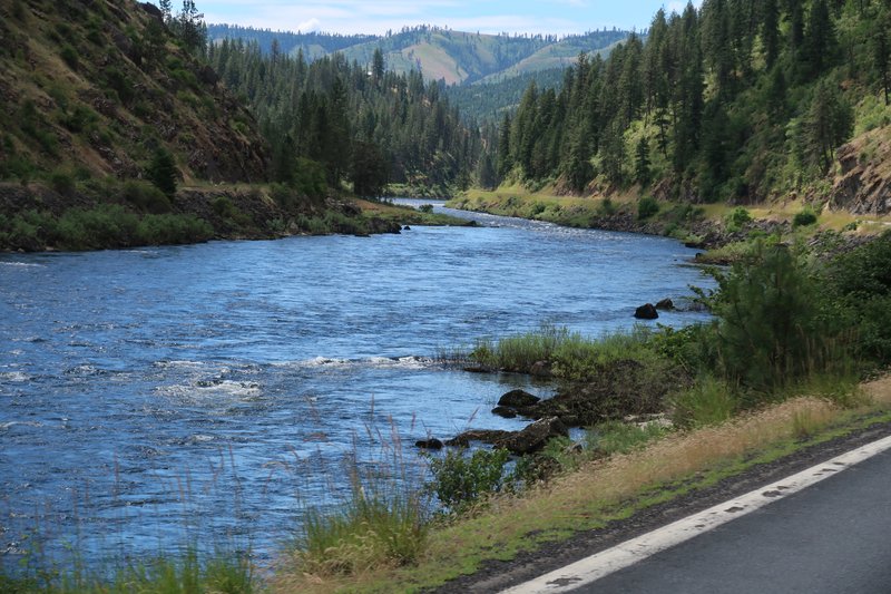
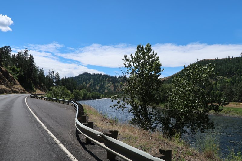
So today I road from Spokane to Missoula Montana via Lolo Pass aka US
Hwy 12. It was a great day with temps in 60 to 75°. Perfect.
First I had to get out of Washington.

I took some interesting back roads in Idaho to join up with Hwy 12. The
pavement was rubbish at best but better than goat quality but not by
much. No photos.
Now on Highway 12 I got the camera out for some fun.
So Lolo Pass is also know as Slow Slow Pass with speed limits of 55 then
50 for many miles. It is also well patrolled, this is the end of the
month and yes there are quotas to be met. DAMHIK.
The trade off is a about 200 miles of extremely scenic river highway that is well paved.

This is the river Lewis and Clark floated down after crossing the
Bitterroot Mountains and there are road signs and turn outs explaining
the journey. The journey over the Bitterroot mountains was very
difficult. They could have avoided the Bitteroots by traveling about 10
miles from Lolo to present day Missoula, using the Clark Fork river, a
tributary of the Columbia river to float all the way to the ocean. They
must have had a Garmin GPS.
Other than the road not much as changed in 220 years.

There are signs saying this is the Lewis and Clark Trail and sometimes
there is a sign advising this is the "Northwest Passage Scenic Byway."
Honestly I don't think that is what President Thomas Jefferson had in
mind when he sent Lewis and Clark and the Corps of Discovery to learn
how the Louisiana Purchase could be exploited economically. Present
day Idaho tourism had other ideas.

As this is a well patrolled road I was doing the speed limit with the
cruise control on with my camera in hand. Instead of waving to other
riders I took a photo.

When the speed limit went from 55 to 50, I was lucky because there an Idaho State Patrol was waiting.
These people are the real risk takers. No shoulder, narrow lanes and
big oversize trucks. This a major transportation corridor.

Miles and miles of this.

Tomorrow I am heading to West Jellystone. I am looking forward to being
in Lamar Valley to watch people behave stupidly with the Bison. It's
free entertainment and Darwin is always nearby. It has gotten so bad
the National Park Service has to station Rangers in popular areas to
keep the tourist safe!
It was a good day to be on the FJR.
Day 2
started the day at 8:30am and rode south on Hwy 93. I road about 70
miles before seeing a turn. At least there are some mountains to the
right to look at.
An eagle was sitting on a fence post. It was so huge I thought is was a
chain saw carving but then it moved it' head or at least I thought it
did. I passed the fence post and finally decided to turn around. The
eagle flew to a tree as I got near. Darn.

Onward and southward to enjoy a short twisty bit near Lost Trail Pass.
At the summit I take Montana Hwy 43 to the Big Hole Battlefield. This
is a great stop to learn some history about the Nez Perce who were simply trying to escape to Canada to preserve a way of life.

Welcome to Montana! There was a lot of straight highway today so the
six speed box came in handy with the engine loping along at 3500 rpm at
about 74 mph. How do you like the six speed box Joey?

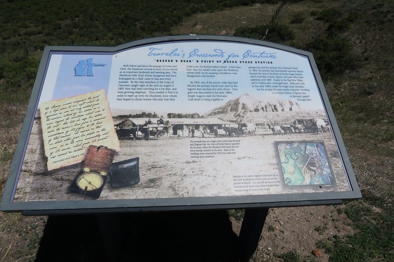
Beaver's Head Rock. Maybe so named by somebody on powerful hallucinations????

I stopped for lunch at Bread Zepp in Sheridan Montana. Great sandwich.
Next stop was at the Earthquake Lake Visitor Center the sight of a
massive landslide in August 1959 due to the Hegben Lake earthquake. The
landslide dammed the Madison River creating Earthquake Lake. The Army
Corp of Engineering quickly create a spillway to drain the lake before
disaster might strike.


The cliff that gave way. There are house size rocks behind my FJR.


Tree stumps from 1959.

A fault scarp.

Tomorrow I am leaving West Jellystone and going to Lamar Valley, Cooke
City Mt., Chief Joseph Pass, Beartooth and then to Red Lodge. I have
found all the tourists head to Old Faithful and the north part of the
park is pretty easy going.
It was a good day to be on the FJR.
Day 3
Started at 7:30am and headed to the West Jellystone entrance gate where
there was a whopping four cars ahead of me. I followed the Madison
river to, wait for it, be patient, here it comes, Madison Junction where
all the cars ahead of me turn right to see the thermal areas including
Old Faithful. I turned left and headed to away from the herds.
It is amazing a vast area of Jellystone is a giant caldera and is smells
like sulfur. It is just mind blowing. What is more interesting is the
Jellystone Hotspot is relatively stable while the North American plate
moves southwest over the hotspot and here is a track
where prior eruptions have occurred. This means Spearfish will be ok,
while there maybe volcanic activity n Winnipeg Canada in a few million
years, so you are good Big John! Actually when it goes off again it
will be catastrophic making Mt St. Helen seem like a baby burping.
Today we get to enjoy some steam vents.


Fantastic views and very little traffic.


I got to see a black bear today.

I arrive at Larmar Valley to see lots of Bison.
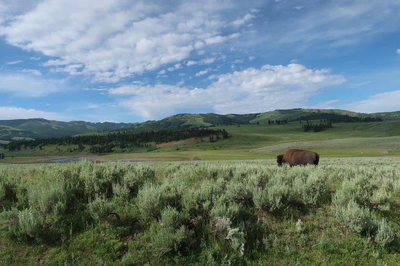
I like this photo.

Bison crossing the road and this unfortunately was shot into the sun so it is blown out.

I got my Darwin in action shot. The driver parked the car on the trail
the bison where using to cross the road. Then they get out of the car.
When the Bison approaches the car the lady moves behind the car. The
people were within 10 feet of the Bison.

I stopped at the coffee shop in Cooke City Montana for a break and a cuppa joe.
Yesterday in West Jellystone I topped of the fuel tank and I was 15
miles out of Cook City when I remembered I didn't fuel up in Cooke City.
I quick check, 105 miles on the tank with 150 miles to go so I was
good.
So far I had been enjoying a tourist pace enjoying the sites and wildlife listening to soft piano music. It was grand!
Arriving at the turn off for Chief Joseph Pass, I hit the after burners
and dialed up some music by a great Canadian band, Bachman Turner
Overdrive. Give me your Money Please! Fred Turner had a great
refrigerator size voice.
On Chief Joseph Pass the twisty bits have odd decreasing radius turns,
no trouble just lean over a bit more. I have been running the FJR i
tour mode to work on making better turns and a smoother ride, just
trying to get a bit better. Big fun!
A rock formation.

Scenery.

What do you do when you reach the end of Chief Joseph Pass and your
hotel reservation is in Red Lodge? You head back the other way and so I
did. It one great down and back.
At Beartooth there was a a few clouds a bit of rain and blue skies.
Makes for a terrible photograph with the photo blown out due to high
dynamic range so I only took a few photos and this one was the best of
the bunch.

Coming off Beartooth traffic got stupid. One guy with a huge Ford Super
Duty pickup with a Connecticut license plate was driving 15 mph, cut
the turn into on coming traffic. A lady pulled out in front of me. I
was happy to have the FJR where take advantage of good handling, braking
a prodigious power.
I arrive at the fuel station in Red Lodge and with 257 miles I used
4.966 gallons. The fuel low indicator didn't come on. Man I love that.
It was a good day to be on the FJR.
Day 04.
The weather forecast for today wasn't great but it was better than it
was two days prior. The weather was coming in from the north, exported
by Canada, to the Northwest US of A. These days ya gotta blame somebody
and this was a weather invasion! ![]()
So I got the idea to swing south. The other choice was to to head to Deer Lodge Montana to see the auto museum.
I wasn't too interested in traveling on Interstate 90 in a rain storm
so I choose this southern route: Red Lodge, Bearthooth, West
Yellowstone, Mud Lake Idaho, the Sun Valley. I just let the GPS pick
the route, other than inserting the West Jellystone via point.
I got an early start, maybe 6:30 to 7:00, or so, and as I walkout to
load the bike it started to rain. Ugh. My good fortune was the rain
stopped before I was underway and it was about 51° out so I was somewhat
confident I could get over Beartooth. With my electric jacket, winter
gloves and heated grips it was a comfortable ride while good portion of
the US of A sweltered in 100° heat. Clearly the Canadian weather
invasion was repelled.
No trip to Beartooth is compete without proof. At the summit it was 40°and no wind. Yes!!!

Odd lighting.

Lighting in this photo is much better.

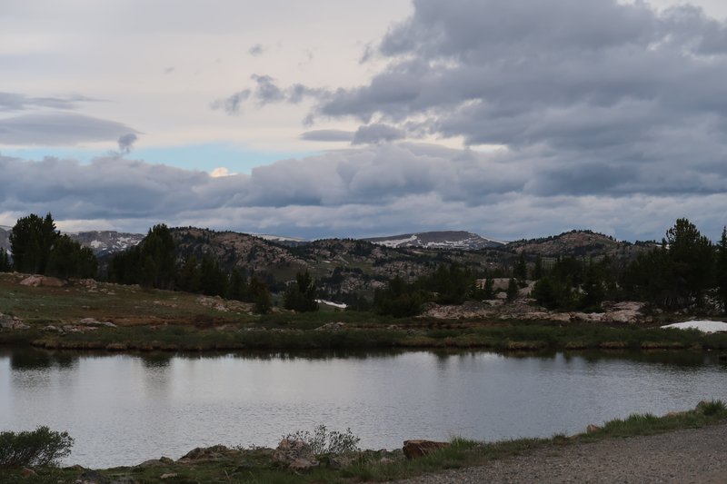
One of the many lakes in the area.

There was no construction as there has been the last 2 or 3 years. The
road has been improved without losing it's character. This waterfall
got a turn out as a result of the construction.

Pilot Peak so says Google Maps.

There was hardly anybody on the road and I had the place to myself just
cruising along. There was two cars ahead of me as I pulled up to the NE
Entrance to Jellystone, just 2 cars. Keep that in mind.
I shot of few photos while riding through Lamar Valley mostly of Bison.

Old Faithful gets all the attention but I think the Bison are pretty
interesting. It is hard to imagine seeing wildlife in the wild so close
anywhere else, while riding a motorcycle, without the risk of getting
eatin' alive.


Heading into trouble?

Nope because I am heading this way, away from those nasty dark clouds. At Tower Junction I take the left and avoid it.

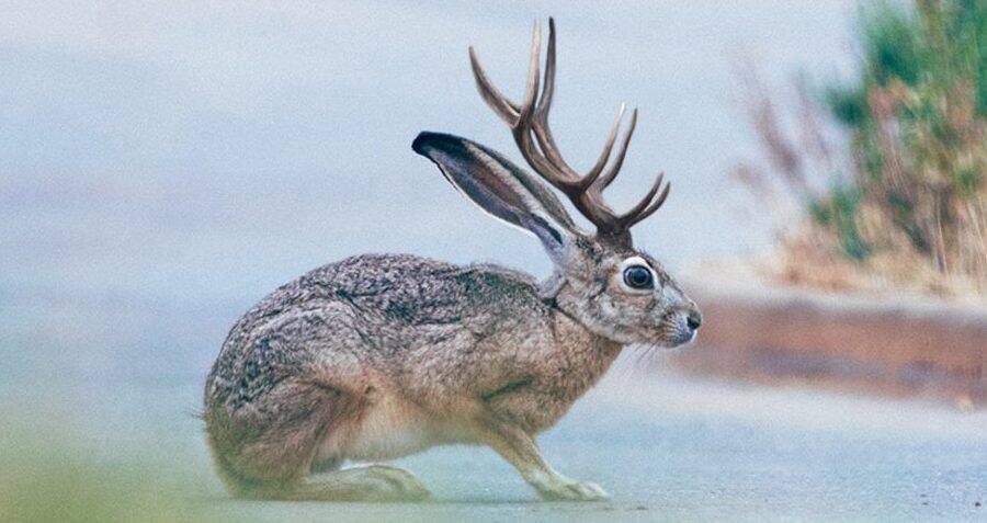
Everybody stopped to see the Prong Horned Antelope so I stopped to take a photo.

I don't get to excited about these critters after all this is Wyoming. It would be more interesting to see a Jackalope.
At Mt. Washburn in Jellystone the traffic thickened and it started to rain on and off all the way to West Jellystone.
The traffic at the West Jellystone entrance was backup as far as the eye could see.

It was a half mile from the West Entrance to West Jellystone and traffic
extend though town along Hwy 20. Traffic in town was all messed up due
to the line up.
I stopped for gas and met 3 guys from France who had rented motorcycles.
One of there bikes a Harley Pan American was not treating them well
with oil burning problems, chain problems and etc. I suggested they
head to Beartooth but they were going to get a replacement for the
ailing bike and head to all the famous National Parks in Utah and
Arizona. I said nothing other than it's hot down there. My lip was
darn near bleeding. They should have headed north up the Icefields
Parkway and toured British Columbia Canada. Good luck guys!
As I left West Jellystone on Hwy 20 the hoards kept coming like Bison
crossing the road in Lamar Valley. I couldn't help thinking the
automobile has become a hindrance to visiting in Yellowstone. I dreamed
of a giant parking lot, where a high capacity tram could take people
to all the sites, Norris Basin, Old Faithful and everything in between
with a lot less stress. What a screwed up mess.
From here to Sun Valley was mostly and uninteresting slog. The interest came from the rain that caught up with me.
I stopped to put on my Aerostich over gloves.

It poured out, the wind was blowing from all different directions, but
my suit repelled the water and the good news was the downpours were 10
minutes.
I passed the opportunity to visit Craters of the Moon
as I might not have made it to Sun Valley before dark. Craters of the
Moon is a destination unto itself, not a 1 hour stop along the way.
Day 5 and 6.
Beyond avoiding weather the idea for slogging it across central Idaho, a
blank slate for interesting paved roads, was to ride from Sun Valley
Idaho to Stanley Idaho, McCall Idaho, Hells Canyon, landing in
Enterprise Oregon. At Lowman Idaho I rode south on Hwy 21 for 11 miles
then back as it is a twist fest with unblemished asphalt. Oh la la. Most
excellent.
I got a later start today about 8:30 or so to let is warm up a bit and
avoid deer as I head north on Hwy 75 to Galena Summit. It was about 52°
a perfect day for a ride. Unfortunately the pavement on Hwy 75 has
seen better days and those days were years and years ago. Liberal use
of tar was applied to the road to fix cracks, holes and tar was layed
over gravel to fix large sections of pavement. It was also just plain
rough and the suspension was working over time. The cooler temperatures
helped keep the tires in place as they crossed the tar snakes and tar
islands, the scenery was top notch and thankfully at Galena Summit the
pavement improved.
After traversing Galena Summit the crummy pavement returned and I
bounced on into Stanley Idaho where I stopped to put on the electric
jacket and winter gloves as the temperature dropped to 46°
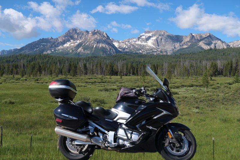
Just outside of Stanley are some great photo ops so I took advantage.

Add the FJR. It looked like a good photo when I shot it but the mountains are too distant.

Take a close up.

Later that night I transferred the photos to my phone and used AI to
copy the FJR and add to the close up photo. This is much closer to what
I had in mind. Is it cheating? What is real and what is processed?
If you move a crooked piece of wood into a photo to add foreground
interest is that cheating or just being creative? There is no black and
white answer. If the photographer is happy with the outcome that's all
that matters.
The pavement from Stanley to Lowman Idaho was in rough shape as well.
It got so bad I slowed down to keep my crown's in place. This is DR650
country, and the pavement isn't suitable for sport touring bikes. Last
year while on the DR650 I popped out forest onto Hwy 21 just south of
Lowman and headed north to find excellent asphalt so while my route
today was east on Lowman Banks road I took a detour by riding Hwy 21
south of Lowman for about 11 miles where it straightened out then I came
back. It was a great down and back.


What a hoot.
The pavement on the Lowman Banks road needs attention.

I wave with the camera.

At Banks I turn right heading to McCall on Idaho 55. It is a great
road, it is also crowded with people who don't use the turn outs. It is
very scenic along the Payette River.

On to Hells Canyon on Hwy 71 where I enjoyed some twisty pavement on the
way to Oxbow and there was no traffic. Excellent. The camera failed
to make an appearance.
The Snake River.

I head north of Forest Service road 39 on the way to the Hells Canyon
Overlook. It starts out well enough with smooth twisty pavement but
soon the pavement is in poor shape.
At Hells Canyon Overlook.

After the Overlook I head to Enterprise Oregon for the night.
All in all given the state of the pavement I endured today, I would not
do this route again. I retrospect I would skipped Sun Valley and headed
for I-84 and on to Baker City Oregon and rode a bit of eastern Oregon
on the way home.
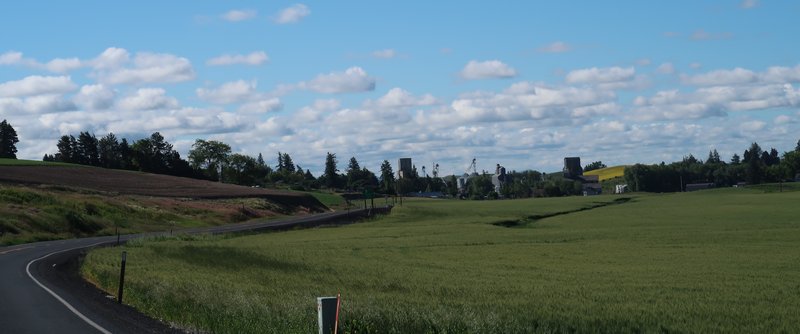
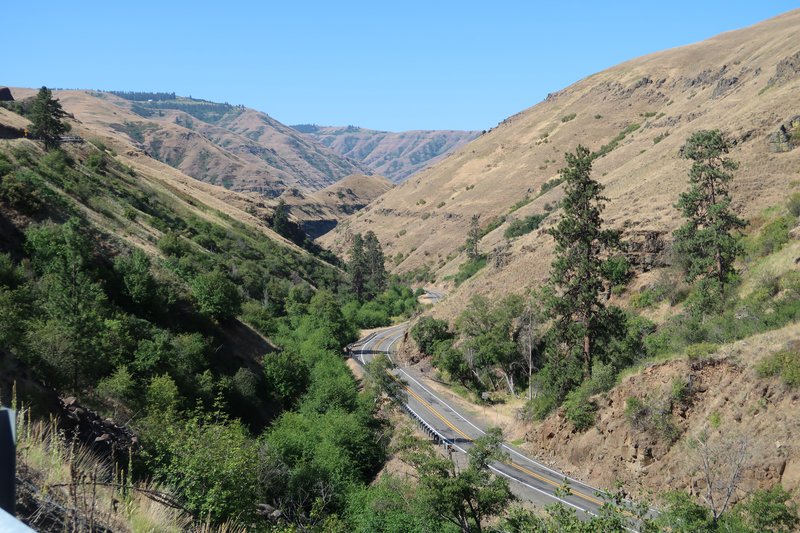
Day 6.
Today is go home day on Hwy 3 in Oregon and Hwy 129, aka Rattlesnake
Grade. This is a nice little route and we have been here before.


In Clarkston Washington I stop at Mac's Cycles to see if they have a BMW
R1250 RS in stock just to see if it would fit. They didn't because it
is a niche bike and nothing was in the pipeline. Side by Sides are what
keeps motorcycle dealers in business these days.
It was up the Old Spiral Highway and on toward Spokane. I wanted to get
off the major road so I took the Wawawai Road. I thought it went
through but it turned to gravel at three miles in. No regrets though as
I took a couple of photos.

I failed to add the FJR to this one. Darn.

The End.


